


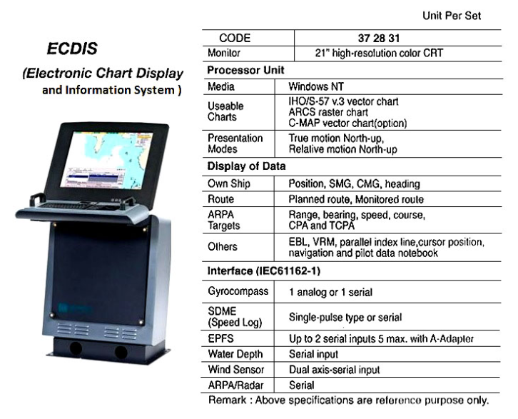
Required by IMO Resolution A.817 (19), IEC 61174, and related IHO (International Hydrographic Office) standards. ECDIS is a real-time geographic information system and accepted as equivalent to paper chart for continuous monitoring of the ship’s position using several positioning systems. It should be type-tested and approved by an official authority and should be used only together with official data and regular updates. Useable charts are derived from an official ENCs (Electronic Navigational Charts) database. This displays electronic charts, navigation lines, ARPA data, user-defined information and offers vessel route planning and continuous monitoring. Accurate position, depth, alarm data and other warning facilities assure the vessel of reliable route monitoring and contributes greatly safer to vessel navigation and efficiency as well as reduced operator workload when compared to using traditional paper charts. The system is composed of monitor and processor unit. Please contact your local supplier for further information.
国际海事组织决议A.817(19)、国际电工委员会61174和相关国际水道测量局(IHO)标准所要求的。ECDIS是一种实时地理信息系统,被公认为等同于纸质海图,用于使用多种定位系统连续监测船舶位置。它应该经过官方机构的类型测试和批准,并且只能与官方数据和定期更新一起使用。可用的海图来自官方的ENCS(电子航海图)数据库。它显示电子海图、航海线、ARPA数据、用户定义的信息,并提供船舶路线规划和持续监控。与使用传统纸质海图相比,准确的位置、深度、报警数据和其他预警设施确保了船舶可靠的航线监控,大大提高了船舶航行的安全性和效率,并减少了操作员的工作量。该系统由监控单元和处理器单元组成。有关更多信息,请联系您当地的供应商。